|
| |
Ít nhiều Chi-tiết về
Tŕi-Liệu vŕ Kỹ-Thuật (tiếp theo)
Vệ-Tinh-
satellite
surveillance
Deconstructing Public Enemy
 www.wired.com/news/news/culture/story/16507.html www.wired.com/news/news/culture/story/16507.html
e National Reconnaissance Office, which maintains the
satellite network for
the NSA, declined to comment on the resolution capabilities of its
satellite
surveillance. And
spokesman Art Haubold pointed out that, legally, his organization is not allowed
to turn its surveillance
systems on the United States.
But it's likely that military's current
satellite
surveillance can track people and
cars from place to place, as shown in the film, and even to give a digital
download that would run like a 10-frame-per-second video, according to Tom
Herring, a geophysics professor at the Massachusetts Institute of Technology.
The satellites he uses for research can resolve images up to 1 meter, based on
technology that's 10 to 15 years old.
"My best guess is that the military could do a factor of 10 better than
that," Herring said. "With an imaging capability of 10 cm, detecting a person
would be possible, and it's plausible that you could see facial
characteristics." Probably not a watch face, though.
|
Andrew Richards outlines how the
satellite-based
vessel monitoring system (VMS) of the South Pacific Forum Fisheries
Agency (FFA) is substantially benefiting local fishermen and the tuna
industry in the Pacific. The FFA VMS is primarily used to ensure that
foreign fishing vessels comply with regulations designed to promote the
sustainable management of the region. The system has already proven to
be successful – reported cases of illegal fishing have remained at a
consistently low level since its introduction in 1999. |
|
http://ictupdate.cta.int/index.php/article/articleview/277/1/53/
|
|
|
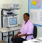
Constable Hansen Kalran of the Vanuatu
Police Maritime Wing |
Constable Hansen Kalran of the Vanuatu Police
Maritime Wing has just logged on to the Internet and has downloaded a
report that gives her cause for concern. Her monitor shows a
satellite map
of the entire exclusive economic zone (EEZ) of Vanuatu and the
coordinates of all fishing vessels currently navigating its waters. All
of the ships are following routes stipulated in their fishing agreements
with the island state, save one: a foreign tuna fishing vessel that
should be on its way home. Instead of directly leaving the EEZ from the
port where it cleared customs, the vessel has stopped off en route,
in all probability to catch extra fish illegally. Kalran wastes no time
– she alerts her colleagues and within a few minutes the Police Maritime
Wing’s patrol boat is preparing to intercept and inspect the suspect
ship.
Dealing with incidents such as this is part of the daily routine of the
Monitoring, Control and
Surveillance
(MCS) Division of the South Pacific Forum Fisheries Agency (FFA). The
division has been successfully operating a
satellite-based
vessel monitoring system (VMS) for its member states in the western and
central Pacific since 1999. The VMS is primarily used to ensure that
foreign fishing vessels comply with regulations designed to promote the
sustainable management and development of and thus to protect the
livelihoods of local small-scale tuna fishermen. Enforcing compliance
has become increasingly difficult, however. The Pacific tuna fisheries –
which support an industry worth $1.8 billion per year – currently
account for one-third of global tuna catches, and everyone wants a piece
of the pie.
To complicate matters, artisanal, subsistence and commercial tuna
fishers are searching for four principal species – skipjack, bigeye,
yellowfin and albacore – as they migrate through the numerous national
jurisdictions and areas of high seas. Approximately 50–60% of the total
catch is taken within the EEZs of FFA members, which cover about 30
million km˛ of ocean. To stem the increase in illegal fishing vessels in
this vast area, most FFA members have reserved their 12 nautical-mile
exclusion zones for fishing by artisanal and subsistence fishermen,
while other islands have put in place 40 nautical-mile exclusion zones
that are off-limits to all foreign fishing vessels. Intruders, however,
are always on the alert for good fishing opportunities and,
increasingly, can only be controlled with the help of advanced ICT
systems such as the FFA VMS.
|
|
|
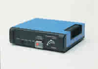
At the core of the FFA VMS is an automatic
location communicator (ALC). Photo: Thrane & Thrane |
How the FFA VMS works
The FFA VMS uses
satellite technology to pinpoint a vessel’s position and then
relays that information to an FFA member monitoring station. At the core
of the system is an automatic location communicator (ALC), a
sophisticated transponder that every fishing vessel operating in FFA
territory is required to have onboard. This device, about the size of a
car radio, consists of an integrated global positioning system unit and
an Inmarsat transceiver, and monitors the vessel’s position, speed and
course. The information is beamed up from an inbuilt aerial to an
Inmarsat satellite,
which is fixed in geostationary orbit above the Pacific. The
satellite
transmits the data to a Land Earth Station in Australia, from where it
is carried by telephone lines to the VMS hub computer at the FFA
Secretariat in Honiara, in the Solomon Islands, for further processing.
This computer identifies any vessels violating fishing regulations and
generates alert reports. The reports are downloaded via an encrypted
Internet connection by the FFA members in whose EEZ the vessels are
operating. In January 2004, for example, FFA members were able to use
the system to track the activities of 883 foreign fishing vessels.
The FFA VMS has already proven to be a cost-effective means of providing
support to the region’s compliance and monitoring programme. According
to recent statistics, reported cases of illegal fishing have remained at
a consistently low level since its introduction in 1999. Its annual
ongoing operating costs, estimated at $845 per vessel, are recovered
from the participating tuna fishing vessels. The system also shows
strong future potential – it could, for example, easily be applied to
track other vessels, such as those that illegally transport live coral
reef fish. The FFA VMS is thus paving the way in the development of a
fully integrated fisheries management approach for the region.
Andrew Richards is FFA’s Monitoring, Control &
Surveillance
manager. For more information, visit
www.ffa.int/www/index.cfm?itemID=8
Hệ-thống “Cáp” Quang
 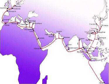
Optical fibre cable systems
Currently,
there are two submarine cable systems landing in Vietnam. The T-V-H
Cable System connects Vietnam with Thailand and Hongkong. And the SMW-3
Submarine Cable System connects Vietnam with 34 countries. From them, it
can connect to other cable systems such as APC, APCN, TPC5 etc. then to
all over the world.
VTI is
participating in the construction the CSC cable systems (Terrestrial
cable system started from China to Vietnam - Laos - Thailand - Malaysia
and ending in Singapore), and joins China US submarine cable system.
Vietnam Telecom International
Add: 97 Nguyen Chi Thanh - Hanoi - Vietnam
Tel: (844) 8410026 / 8366456 Fax: (844) 8357393
Email: business@vti.com.vn
|
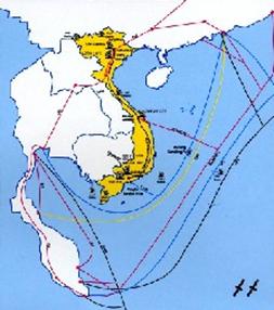
Thŕnh-phố Hoŕng-Trường giữa Biển Đông
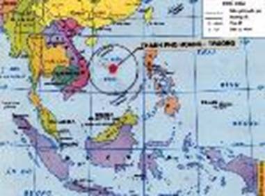
Thŕnh phố
Hoŕng - Trường sẽ có giá trị 1500 tỷ USD sau khi hoŕn thiện. Tiến sĩ Trần Văn
Khoát. Tổng giám đốc Keystone (Công ty
Quản lý phát triển đá Đỉnh vňm)
TS Trần Văn Khoát từng có ý tưởng xây một thŕnh phố nổi
giữa Hoŕng Sa vŕ Trường Sa, vŕ nhờ quy mô bề thế của công trěnh nŕy, quốc tế sẽ
can thiệp để không ai cňn nhúng mũi vŕo hải phận của Việt Nam. Xin xem bŕi phỏng
vấn ông tręn Vietnamnet ngŕy 29/02/2004 do Đỗ Diễm Huyền thực hiện.
|
 Chiến-Lược
Biển Đông
Chiến-Lược
Biển Đông
