|
| |
Hải-phận Việt-Nam vŕ Khmer
phân-chia theo đường Brévíe
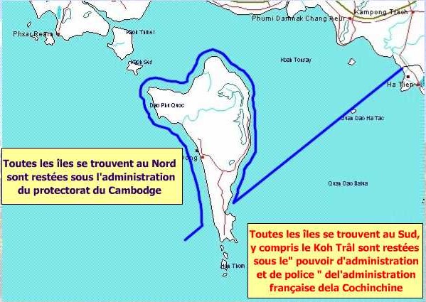
Hải-phận với Campuchia
Trong buổi Hôi Thảo về Phát Triển Khu Vực
Châu Á Thái Běnh Dương vŕ
Tranh Chấp Biển Đông ngŕy 15 vŕ 16 tháng 8 năm 1998 tại New York City
Ông Lę Minh Nghĩa
Nguyęn Trưởng ban Ban Bięn giới của Chính phủ VN đă
trěnh-bŕy về
NHỮNG
VẤN ĐỀ VỀ CHỦ QUYỀN LĂNH THỔ GIỮA
VIỆT NAM VŔ CÁC NƯỚC LÁNG GIỀNG
Ông Nghĩa
đă phát-biểu
về việc thương-thuyết hải-phận với Campuchia như sau:
Trước năm 1964, quan điểm cơ bản
của phía Campuchia về bięn giới lănh thổ giữa hai nước lŕ đňi Việt Nam trả lại
cho Campuchia 6 tỉnh Nam Kỳ vŕ đảo Phú Quốc.
Từ năm 1964 - 1967, Chính phủ
Vương quốc Campuchia do Quốc trưởng Norodom Sihanouk đứng đầu chính thức đề nghị
Việt Nam công nhận Campuchia trong đường bięn giới hỉện tại, cụ thể lŕ đường
bięn giới tręn bản đồ tỷ lệ 1/100.000 của Sở Địa dư Đông Dương thông dụng trước
năm 1954 với 9 điểm sửa đổi, tổng diện tích khoảng 100 km2. Tręn biển,
phía Campuchia đề nghị các đảo phía Bắc đường do Toŕn quyền Brévié vạch năm 1939
lŕ thuộc Campuchia, cộng thęm quần đảo Thổ Chu vŕ nhóm phía Nam quần đảo Hải Tặc.
Trong năm 1967, Việt Nam Dân chủ
Cộng hoŕ vŕ Mặt trận dân tộc giải phóng miền Nam Việt Nam đă chính thức công
nhận vŕ cam kết tôn trọng toŕn vẹn lănh thổ của Campuchia trong đường bięn giôi
hiện tại (công hŕm của Việt Nam không nói tới vấn đề chủ quyền đối với các đảo
tręn biển vŕ 9 điểm mŕ Campuchia đề nghị sửa đổi về đường bięn giới tręn bộ).
Ngŕy 27/12/1985 Việt Nam vŕ Cộng
hoŕ nhân dân Campuchia đă ký Hiệp ước hoạch định bięn giới quốc gia tręn cơ sở
thoả thuận năm 1967. Thi hŕnh Hiệp ước, hai bęn đă tiến hŕnh phân giới tręn thực
địa vŕ cắm mốc quốc giới từ tháng 4/1986 đến tháng 12/1988 được 207 km/1137 km,
tháng 1/1989 theo đề nghị của phía Campuchia, hai bęn tạm dừng việc phân giới
cắm mốc.
Tręn biển, ngŕy 7/7/1982 hai
Chính phủ ký Hiệp định thiết lập vůng nước lịch sử chung giữa hai nước vŕ thỏa
thuận: sẽ thương lượng vŕo thời gian thích hợp để hoạch định đường bięn giới
tręn biển, lấy đường gọi lŕ đường Brévié được vạch ra năm 1939 với tính chất lŕ
đường hŕnh chính vŕ cảnh sát lŕm đường phân chia đảo giữa hai nước.
Với Chính phủ Campuchia thŕnh
lập sau khi ký Hiệp ước hoŕ běnh về Campuchia năm 1993 , năm 1994, 1995 Thủ
tướng Chính phủ hai nước đă thoả thuận thŕnh lập một nhóm lŕm việc cấp chuyęn
vięn để thảo luận vŕ giải quyết vấn đề phân giới giữa hai nước vŕ thảo luận
những biện pháp cần thiết để duy trě an ninh vŕ ổn định trong khu vực bięn giới
nhằm xây dựng một đường bięn giới hoŕ běnh, hữu nghị lâu dŕi giữa hai nước. Hai
bęn thoả thuận trong khi chờ đợi giải quyết những vấn đề cňn tồn đọng về bięn
giới thě duy trě sự quản lý hiện nay.
Thực hiện thoả thuận giữa Thủ
tướng Chính phủ hai nước nhân dịp Thủ tướng Ung Huốt sang thăm Việt Nam đầu
tháng 6/1998, nhóm chuyęn vięn lięn hơp về bięn giới Việt Nam - CPC đă họp tại
Phnom Pęnh từ ngŕy 16 - 20/6/1998. Trong cuộc họp nŕy hai bęn đă trao đổl về
việc tiếp tục thực hiện các Hiệp ước, Hiệp định về bięn giới giữa hai nước đă ký
trong những năm 1982, 1983, 1985. Hai bęn đă dŕnh nhiều thời gian thảo luận một
số vấn đề về quan điểm của hai bęn lięn quan đến bięn giới biển vŕ bięn giớl
tręn bộ với mong muốn xây dựng đường bięn giới giữa hai nước trở thŕnh đường
bięn giới hoŕ běnh, hữu nghị vŕ hợp tác lâu dŕi.
Hai bęn đă thống nhất kěến nghị
lęn Chính phủ hai nước tiến hŕnh thŕnh lập Uỷ ban lięn hơp với những nhiệm vụ:
- Soạn thảo Hiệp ước về hoạch
định bięn giới biển vŕ Hiệp ước bổ sung Hiệp ước hoạch định bięn giới quốc gia
trěnh lęn chính phủ hai nước.
- Chỉ đạo việc phân giới tręn
thực địa vŕ cắm mốc quốc giới.
- Giải quyết mọi vấn đề lięn
quan đến việc thực hiện Hiệp định về quy chế bięn giới giữa hai nước.
Qua trao đổi về đường bięn giới
biển, phía CPC kięn trě quan điểm muốn lấy đường do Toŕn quyền Brévié vạch ra
tháng 1/1939 lŕm đường bięn giới biển của hai nước.
Ta đă nói rő lŕ ta không chấp
nhận đường Brévié lŕm đường bięn giới biển giữa hai nước vě:
1. Đường Brévié không phải lŕ 1
văn bản pháp quy, chỉ lŕ một bức thư (lettre) gửi cho Thống đốc Nam Kỳ đồng gửi
cho Khâm sứ Pháp Ở CPC. Văn bản đó chỉ có mục đích giải quyết vấn đề phân định
quyền hŕnh chính vŕ cảnh sát đối với các đảo, không giải quyết vấn đề quy thuộc
lănh thổ;
2. Cả hai bęn không có bản đồ
đính kčm theo văn bản Brévié vě vậy hiện nay ít nhất lưu hŕnh 4 cách thể hiện
đường Brévté khác nhau: Đường của Pôn Pốt, đường của Chính quyền miền Nam Việt
Nam, đường của ông Sarin Chhak trong luận án tiến sỹ bảo vệ ở Paris sau đó được
xuất bản với lời tựa của Quốc trưởng Norodom Sihanouk, đường của các học giả Hoa
Kỳ.
3 . Nếu chuyển đường Brévié
thŕnh đường bięn giới biển thě không phů hợp với luật pháp quốc tế, thực tiễn
quốc tế, quá bất lợi cho Việt Nam vŕ nęn lưu ý lŕ vŕo năm 1939 theo luật pháp
quốc tế lănh hải chỉ lŕ 3 hải lý, chưa có quy định về vůng đặc quyền về kinh tế
vŕ thềm lục địa thě đường Brévié lŕm sao có thể giải quyết vấn đề phân định lănh
hải theo quan điểm hiện nay vŕ phân định vůng đặc quyền về kinh tế vŕ thềm lục
địa.
Phía Việt Nam đă đề nghị hai bęn
thoả thuận: áp dụng luật biển quốc tế, tham khảo thực tiển quốc tế, tính đến mọi
hoŕn cảnh hữu quan tręn vůng biển hai nước để đi đến một giải pháp công bằng
trong việc phân định vůng nước lịch sử, lănh hải, vůng đặc quyền kinh tế, thềm
lục địa của hai nước.
Trong thời-gian gần đây, người
ta không thấy Hŕ Nội thay đổi quan-điểm nŕo rő-rệt.
Nếu tň mň, xin Quý Vị xem thęm một số
quan-điểm phía Cambodia, cũng posted trong site nŕy.
Khmer exterminated the 515 Vietnamese
residents of Poulo
Panjang (Tho Chu island) in May 1975:
http://www.camnet.com.kh/cambodia.daily/selected_features/cd-14-02-04.htm
The Cambodia Daily , WEEKEND
Saturday, February 14-15, 2004
Defining Cambodia
By Michelle Vachon
The Cambodia Daily
Sixty-five years ago, a French colonial administrator made a decision on
maritime borders between
Cambodia and Cochin-China, as the southern part of Vietnam was then
called.
Jules Brevie hoped his decision would resolve, once and for all, a long dispute.
Meant to clarify which islands in the Gulf of Thailand fell under the
jurisdiction of either Cambodia or Cochin-China, Jules Brevie's administrative
notice of Jan 31, 1939, has been at the heart of all maritime border quarrels
between Cambodia and Vietnam ever since.
Every political regime in Cambodia has raised the issue, which still triggers
heated debates and often puts the two countries at odds with each other.
In the 1960s, then-Prince Norodom Sihanouk requested an international conference
to settle the matter once and for all, and to protect Cambodia's territory
through peaceful means.
No such approach suited the
Khmer Rouge, who bombarded the
Vietnamese island of Phu Quoc (Koh Trac in
Khmer) and exterminated the 515 Vietnamese residents of
Poulo
Panjang (Tho Chu island) in May 1975,
said Raoul Marc Jennar in his 1997 doctorate thesis, "Contemporary Cambodian
Borders."
The only agreements on maritime borders between Cambodia and Vietnam were signed
in July 1982. They were part of a series of pacts that were based on the Treaty
of Peace, Friendship and Cooperation signed on Feb 18, 1979Ńshortly after
Vietnam had ousted the Khmer
Rouge regime, taken over the country and installed a Hanoi-friendly government.
Valid for 25 years, terms of the agreement indicate that the 1979 treaty will be
automatically renewed for periods of 10 years, unless revoked the year before
renewal by either country, said Var Kim Hong, chairman of Cambodia's Border
Committees.
As far as he knows, no measure has been taken to annul the agreement, and it
should get renewed on Wednesday, he said.
But the renewal will not be accompanied by a new agreement on maritime borders.
In this area, negotiations continue, Var Kim Hong said.
The debate, which the Sam Rainsy Party and Funcinpec rekindled during the
national election campaign of 2003, has made strange allies.
The figure of 95,000 square km, often-quoted as the waters over which Cambodia
should have jurisdiction, was given legal status during the Lon Nol regime,
Jennar said.
The administration, which had ousted then-Prince Sihanouk in 1970, issued a
decree in 1972 setting the size of the country's continental shelf and claiming
Cambodia's rights over it.
The territory covered a third of the waters claimed by Thailand, and
three-quarters of the zone claimed by Vietnam, said Jennar. The lure of possible
oil and gas contracts in the gulf prompted Cambodia and its neighbors to act
without consulting each other, he said. Cambodia and Vietnam's claims overlapped
by 60,000 square km.
Four years later, the Khmer
Rouge adopted King Sihanouk's position during their preliminary talks with the
Vietnamese, and picked the Brevie line to define the maritime borders, said
Jennar. But the Pol Pot regime soon put an end to the May 1976 meeting, and
progressively turned to arms against Vietnam, he said.
Brevie was governor general of IndochinaŃwhich included Cambodia, Laos and the
Vietnamese territoriesŃwhen he issued his notice in 1939. He was attempting to
end disagreements that had started in the 19th century.
In the late 1870s, Cochin-China Governor Le Myre de Villiers led a group of
French businessmen who replaced navy officers in the Cochin-China government,
wrote Alain Forest in his 1980 book, "Cambodia and the French Colonization." Not
only did they want land for plantations and good fishing grounds, but they also
envisioned Cambodia's annexation, he said.
Unlike Cambodia, which was an independent country with a king and government
that had requested France's protection, Cochin-China was a French colony.
Expanding Cochin-China's territory was an ambition of France.
Huynh de Verneville, the French administrator assigned to Cambodia, tried to
limit Cochin-China's expansion project, but with limited success, said Forest.
Still, Cambodia, which was caught between its two expansionist neighbors in the
19th century, extended its territory during the French Protectorate.
Using the border on land as his starting point, Brevie traced a straight line
into the Gulf of Thailand, indicating that the waters and islands north of the
line would be administered by Cambodia, and islands and waters south of it by
Cochin-China. However, because Phu Quoc had been under Cochin-China's
administration since the 1860s, he left it to Vietnam, making the line pass 3 km
north of the island.
Brevie noted that the islands close to the Cambodian coast were geographically
linked to Cambodia, and therefore should fall under its jurisdiction.
Up to then, no document had shown whether the islands had been part of Cambodia
or Cochin-China. In 1913, the French administrator of Cochin-China had said that
he could find no proof of jurisdiction, reported Sarin Chhak in his 1966 book,
"Cambodia's Borders."
Brevie set his line for the purpose of dividing administrative and police duties
among the two jurisdictionsŃhe never intended his line to be considered the
maritime border, he wrote.
Sarin Chhak said that Brevie even pointed this out in his notice by writing, "It
is understood that the above pertains only to the administration and policing of
these islands, and that the issue of the islands' territorial jurisdiction
remains entirely reserved."
However, this paragraph of Brevie's letter, printed in Sarin Chhak's book, does
not appear in the letter at the National Archives in Phnom Penh. The original
document on file consists of a cover letter with Brevie's signature, which is
attached to his letter on the dividing line; the documents are numbered 867 and
868, written in the same hand, obviously numbered one after the other.
Except for this discrepancy over the paragraph most frequently quoted to
illustrate the intent and legal value of Brevie's line, the rest of the document
is identical to the letter reproduced in Sarin Chhak's book.
In any case, the French administrators of Indochina could not know Cambodia,
Laos and Vietnam would gain their independence, and that their administrative
land and sea dividing lines would become international boundaries.
In 1957, Cambodia became the first country in the Gulf of Thailand to define its
territorial waters at a time when international laws on the subject were just
developing, said Jennar. The decree of Dec 30 set the width of the country's
territorial waters at five nautical miles, or 9.26 km; and its contiguous waters
at 7
nautical miles, or 13 km. These were modest and reasonable claims, said Jennar.
Cambodia maintained its "historical rights" over Phu Quoc. In a separate letter,
Prince Sihanouk ordered the Royal Navy to protect all islands, especially
Poulo
Panjang,
Poulo Wai and Koh
Tang, whose occupation, he wrote, "are essential to the good development and
maritime future of the Port of Kompong-Som."
In 1960, Cambodia was the first country in the Gulf to sign the 1958 Geneva
Convention on the Territorial Sea and Contiguous Zone. The National Assembly
approved it in 1963, but it wasn't enacted until 1968.
In 1969, Cambodia extended its territorial waters to 12 nautical miles, or 22.2
km, which is in accordance with international laws.
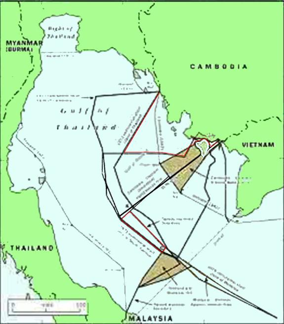
The decree of 1982 redefined the country's baseline from which territorial
waters are measured. Instead of being close to the shore as it was in 1957, the
baseline links Cambodia's distant islands from the Thai border to
Poulo Wai.
The document recognized for the first time that
Poulo Wai belongs to
Cambodia. It set the country's Economic Exclusive Zone and its continental
shelf, which are nearly identical, at the customary 200 nautical miles, or 370
km.
In addition, a 1982 agreement maintains all international rights to territorial
waters and the continental shelf and establishes "historic waters" on each side
of the Brevie line, a zone over which both Cambodia and Vietnam were to have
jurisdiction, and in which people from both countries would be allowed to fish.
During the first meetings of the Cambodian-Vietnamese joint border commission,
Vietnam rejected the Brevie line as a maritime border, while Cambodia insisted
on keeping it, said Alain Gascuel, who has closely followed the work of the
commission.
Does the work of the commission move in an uncommonly slow fashion? Not really,
said Martin Pratt, director of the International Boundaries Research Unit for
the University of Durham in the United Kingdom. "Maritime boundary delimitation
can be a difficult process at the best of times. In semi-enclosed seas with lots
of islands, the challenges are even greater."
Before the start of the negotiations, Cambodia filed a complaint with the UN
against Vietnam and Thailand; in 1997, their governments signed an agreement
defining their continental shelves and economic zones in the Gulf of
ThailandŃwithout consulting Cambodia. Incidents like this one have convinced Lao
Mong Hay, the head of the Legal Unit at the Center for Social Development, that
Cambodia should submit its case to an international court or organization whose
decision would be binding, he said.
He also believes that, unless Cambodia is in a position to manage and control
its territorial waters, having jurisdiction over portions of the Gulf of
Thailand will not mean very much.
Cambodia should invest in rebuilding its navy, and in training people to run
offshore oil and gas operations, and other maritime departments, Lao Mong Hay
suggested.
Những vůng Hải-phận Đặc-Quyền Kinh-Tế của Việt-Nam trong vịnh
Phú-Quốc. |
 Chiến-Lược
Biển Đông
Chiến-Lược
Biển Đông